Gaza Strip Through Satellite Lenses
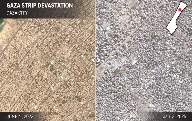
The Gaza Strip, a densely populated region with a history of political and humanitarian struggles, has endured profound devastation as a result of the Israel-Hamas war. Recent satellite imagery offers a stark visual representation of the destruction, juxtaposing vibrant pre-war scenes against post-conflict devastation.
This article delves into the impacts of the conflict, supported by compelling satellite data that highlights the extent of the damage.
A Snapshot of Vibrancy and Challenge

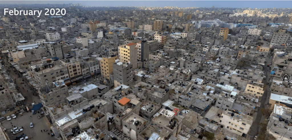
Before the onset of the recent war, the Gaza Strip displayed a mix of bustling urban areas, sprawling agricultural zones, and densely populated refugee camps. Satellite imagery from earlier months reveals:
- Urban Centers: High-resolution images depict cities such as Gaza City and Khan Younis teeming with life, with crowded streets, active markets, and sprawling residential complexes.
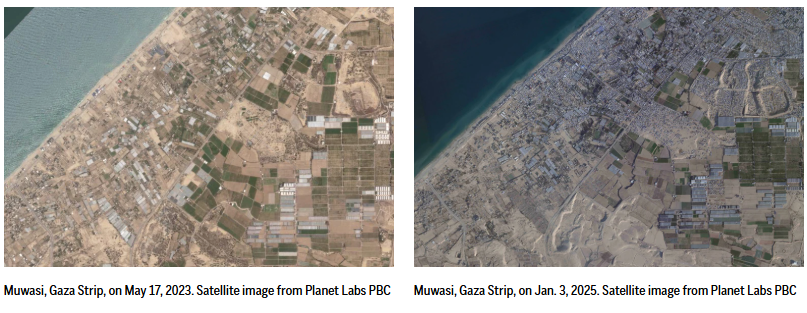
- Agricultural Lands: The green patches of farmland reflect the region’s reliance on local agriculture, a vital source of sustenance and income for many residents.
- Critical Infrastructure: Key facilities, including hospitals, schools, and water treatment plants, appeared intact, catering to a population of over two million people.
Despite enduring ongoing socio-economic challenges and a blockade, the Gaza Strip maintained a semblance of stability. However, this fragile balance was irreparably disrupted when conflict erupted.
A Timeline of Devastation


The war, marked by intense aerial bombardments and retaliatory rocket attacks, led to widespread destruction. Satellite imagery has played a crucial role in documenting the escalation:
- Initial Strikes: Early images show targeted airstrikes that left isolated craters in urban areas.
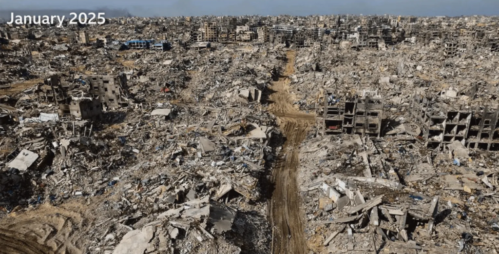
- Escalation: As the conflict intensified, entire neighborhoods were flattened, with residential buildings reduced to rubble.
- Critical Facilities: Schools, hospitals, and power plants suffered extensive damage, further straining an already fragile humanitarian situation.
The imagery provides an unbiased account of the sheer scale of destruction, serving as evidence of the war’s toll on human lives and infrastructure.
A Landscape of Ruins
The aftermath of the conflict is poignantly captured in satellite photos, showcasing the stark contrast between pre- and post-war Gaza. Key observations include:
Widespread Rubble
Entire neighborhoods, once home to thousands of families, are now vast expanses of debris. Areas such as Beit Hanoun and Shujaiya have been particularly hard-hit, with satellite images revealing:
- The obliteration of multi-story apartment complexes.
- Streets and roads rendered impassable by rubble.
Decimated Infrastructure
Essential infrastructure has been decimated, plunging the region into a humanitarian crisis. Satellite photos indicate:
- Damaged Power Grids: Blackouts are evident from the loss of functional power lines.
- Water Supply Disruption: Destroyed pipelines and treatment facilities leave thousands without access to clean water.
Environmental Impact
The conflict has left scars on the environment, visible from above:
- Farmland Devastation: Once-lush fields are now barren, unable to sustain crops.
- Pollution: Fires and debris have contributed to visible contamination of land and waterways.
A Crisis Unfolds
The war’s devastation, as illustrated by satellite imagery, underscores a mounting humanitarian crisis:
Displacement of Populations
Over one million residents have been displaced, seeking refuge in overcrowded shelters. Satellite imagery of refugee camps shows:
- Expansion of temporary structures.
- Overcrowded conditions that strain resources.
Healthcare Collapse
With hospitals severely damaged, the healthcare system struggles to address the growing number of casualties. Satellite photos highlight:
- Destroyed medical facilities.
- Makeshift clinics set up in open spaces.
Economic Ruin
The destruction of commercial hubs and industrial zones has left the local economy in tatters. Observations from satellite data include:
- Shuttered factories and workshops.
- Abandoned marketplaces that once thrived with activity.
Challenges and Hope
While the destruction captured by satellite imagery is harrowing, efforts to rebuild are already underway. The path to recovery involves addressing critical needs:
Immediate Aid
International organizations are mobilizing to provide emergency relief, including:
- Food and water distribution.
- Medical supplies for injured and displaced populations.
Long-Term Reconstruction
Rebuilding Gaza’s infrastructure requires substantial resources. Satellite technology will play a pivotal role in:
- Mapping reconstruction efforts.
- Monitoring progress to ensure effective use of aid.
Strengthening Resilience
Future planning must focus on creating a more resilient Gaza. This includes:
- Sustainable Infrastructure: Building structures that can withstand future conflicts.
- Environmental Restoration: Rehabilitating farmland and waterways to ensure food security.
The Role of Satellite Imagery in Documenting Wars

Satellite technology has proven indispensable in documenting the destruction caused by conflicts. It provides:
- Unbiased Evidence: High-resolution images offer a neutral perspective on the extent of damage.
- Aid Allocation: Mapping destruction helps prioritize areas most in need of assistance.
- Accountability: Imagery serves as evidence in international efforts to address war crimes and rebuild.
The satellite photos of the Gaza Strip before and after the Israel-Hamas war offer a sobering reminder of the devastation wrought by conflict. These images not only highlight the extensive damage but also emphasize the urgent need for humanitarian aid and long-term rebuilding efforts. As Gaza begins its journey toward recovery, the role of technology and international collaboration will be crucial in fostering hope and resilience.
